Arbeitsschritte ´
- Quantum-GIS-Projekt -

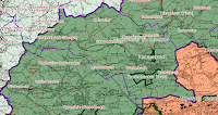
Aufgabe war es ein Quantum-GIS-Projekt zu erstellen. Auf der Grundlage einer Topographischen Karte 100 musste man die Verwaltungsgrenzen der Landkreise, Verwaltungsgrenzen und Ortsgemeinden darstellen. Zusätzlich waren die Naturschutzgebiete darzustellen.
1.Schritt: GRUNDEINSTELLUNGEN
Zunächst muss man die Grundeinstellungen vornehmen. Hierzu wählt man Einstellungen und dann Optionen .
Es öffnet sich ein neues Fenster:
The tab tools choose "Bessel 1841" as ellipsoid to Distanzberechung. In KBS
register to enable "KBS Names.
Step 2: PROJECT SETTING
are now carried out the project settings. This, choose Settings, and then Project Settings. It opens a new window:
the General tab you can now Project title "Exercise 1" here. The map units are set to "meter" and save paths to "relative". In the register
Coordinate Reference System (KBS) to set DHDN / Gauss-Kruger zone 2 (EPSG ID 31 466) a.
Next, you select the toolbar File, then Open New Project.
Step 3: Insert
With the tool "Raster Layer Add" to import the first topographic map 100 as a basis. Then the files for counties, unitary councils, local communities and protected areas with the tool "Add vector layer.
Step 4: EDIT
Now you arrange the layers in a meaningful order: Topographic map 100 protected areas local communities unitary councils counties
Step 5: EDIT THE LAYER
Right-click on a layer can be the properties of the layer . Edit
representation: The layer must have veschiedene outline strengths and colors and fill colors. The nature reserves have to be additionally marked with a hatch. Additionally, you can edit the transparency of the layer, so that all the major lines identified.
caption: will local communities and protected areas now in matching colors labeled
Step 6: Save
If your settings were and the card is ready. The project can be saved. For this you choose File, then Save Project as
.
0 comments:
Post a Comment