Friday, July 30, 2010
Monday, July 5, 2010
Judi Barrett's Awards Won
GIS Exercise 3
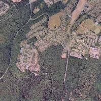
GIS Exercise 3 - digitizing an aerial image
was the object of this exercise is an aerial view of The University of Kaiserslautern and the surrounding area by using Quantum GIS digitized. The digitization of the aerial photograph should be comprehensively and superimposition.
Step 1.1 - Digitizing
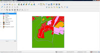
Man first uploads the image in Quantum GIS. Then activate the formula bar "go digital. There are various tools (line, point, polygon) to edit the image. Choose "digitize Polygon" tool.
Step 1.2
So that the individual polygons are exactly together and not overlap, select "Project Settings", then "General" tab: Here you turn on the "Capture Options" to "avoid duplication of polygons" and. The surfaces merge together so.
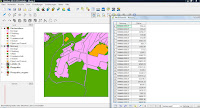
Step 2 - Balance
area is chosen for "vector" "Geoverarbeitungswerkzeuge" and then "dissolve". It opens a new window. A new layer is created and added. Thus, the entire areas are combined into a single area and then saved as a record of use. First sind die Farben der Flächen falsch. Daher muss man als nächstes den Stil des Nutzungslayers speichern, indem man durch Rechtsklick zu den Eigenschaften gelangt und dort "Stil speichern" wählt. den gespeicherten Stil lädt man nun im Lyer der Flächenbilanz hoch. Das bewirkt, dass die Flächenangaben jeweils für die einzelnen Kategorien generiert werden und die Farben angepasst sind.
Als nächstes öffnet man die Attributtabelle des Nutzungslayers (im Bearbeitungsmodus!) und wählt dann den Feldrechner: Einstellungen:
Ausgabefelname:"Fläche", Dezimalzahl, Genauigkeit 2
Im linken Feld wählt man "Fläche", im rechten Feld "Alle Werte"; dann drückt man das Feld "Fläche" -> Ok
appear in the attribute table now has a new column. These values are added together and then give a value of about 3, 99 million.
When you create the first balance sheet problems have occurred. The cause of the problem was that not all areas were colored. Repeated follow the lines but then it worked. Another problem was that were dyed to create the balance in both surface layers all the same fields. 
GIS Exercise 3 - digitizing an aerial image
was the object of this exercise is an aerial view of The University of Kaiserslautern and the surrounding area by using Quantum GIS digitized. The digitization of the aerial photograph should be comprehensively and superimposition.
Step 1.1 - Digitizing
Man first uploads the image in Quantum GIS. Then activate the formula bar "go digital. There are various tools (line, point, polygon) to edit the image. Choose "digitize Polygon" tool.

Step 1.2
So that the individual polygons are exactly together and not overlap, select "Project Settings", then "General" tab: Here you turn on the "Capture Options" to "avoid duplication of polygons" and. The surfaces merge together so.

Step 2 - Balance
area is chosen for "vector" "Geoverarbeitungswerkzeuge" and then "dissolve". It opens a new window. A new layer is created and added. Thus, the entire areas are combined into a single area and then saved as a record of use. First sind die Farben der Flächen falsch. Daher muss man als nächstes den Stil des Nutzungslayers speichern, indem man durch Rechtsklick zu den Eigenschaften gelangt und dort "Stil speichern" wählt. den gespeicherten Stil lädt man nun im Lyer der Flächenbilanz hoch. Das bewirkt, dass die Flächenangaben jeweils für die einzelnen Kategorien generiert werden und die Farben angepasst sind.
Als nächstes öffnet man die Attributtabelle des Nutzungslayers (im Bearbeitungsmodus!) und wählt dann den Feldrechner: Einstellungen:
Ausgabefelname:"Fläche", Dezimalzahl, Genauigkeit 2
Im linken Feld wählt man "Fläche", im rechten Feld "Alle Werte"; dann drückt man das Feld "Fläche" -> Ok
appear in the attribute table now has a new column. These values are added together and then give a value of about 3, 99 million.

When you create the first balance sheet problems have occurred. The cause of the problem was that not all areas were colored. Repeated follow the lines but then it worked. Another problem was that were dyed to create the balance in both surface layers all the same fields.
Subscribe to:
Comments (Atom)